


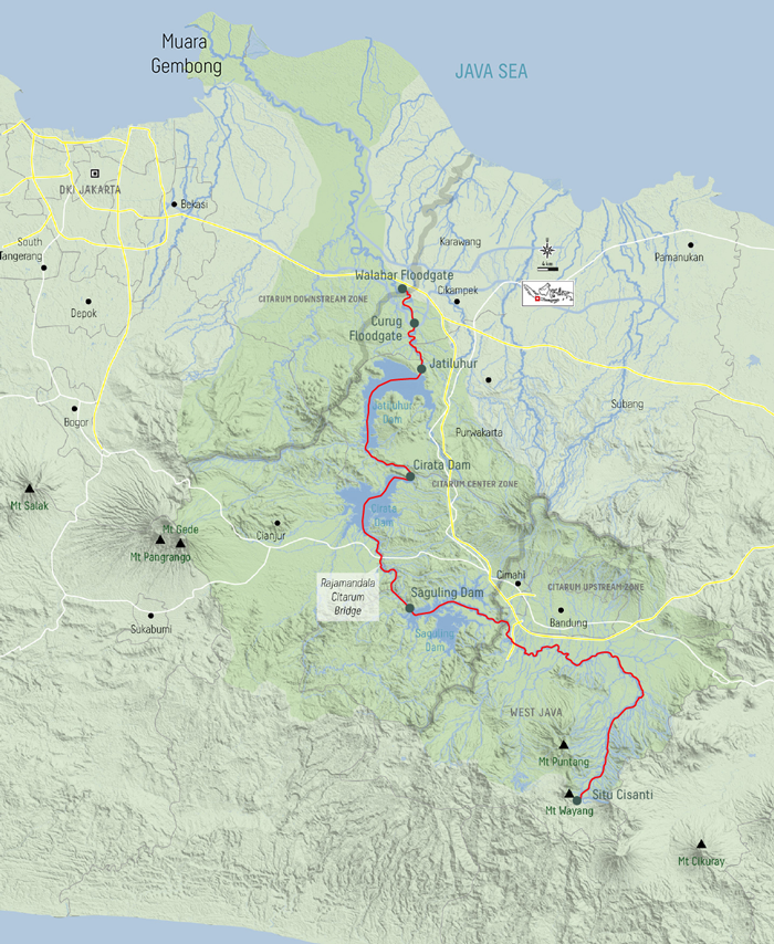
Hopes of infrastructure development rest on the Citarum River. During the New Order era, there was a plan to develop hydropower plants in nine locations along the river. There was even a plan to develop a hydropower station in Citarum (Kompas, Aug. 9, 1980).
Long before that, Dutch irrigation expert W.J. van Blommestein planned to develop 17 rivers in Java, including the Citarum. Van Blommestein’s plans are well documented in his working paper titled “A Federal Welfare Plan for the Western Part of Java” (1948).
Decades later, what infrastructure has been developed along the Citarum River?
Walahar Floodgate
“Ceremonials, somber speeches and champagne. This was witnessed by hundreds of people. However, those who have constructed it for years, those who devoted all their love and ingenuity to the work, had a different picture. This end point of merriment was only the beginning in their minds. It was true: The real work had yet to begin,” Walahar, 1925, as quoted from the book Water Over Sawah’s, H.J. Paris, 1949, written by C. Swaan-Koopman.
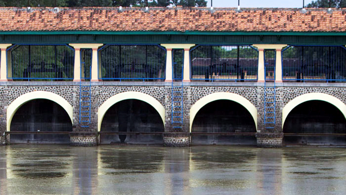 Kompas/AGUS SUSANTOThe Walahar Dam in Walahar village, Klari district, Karawang regency, West Java, as photographed on Wednesday (24/4/2013). The yellow-painted dam, a legacy of Dutch colonialism, used to be called Parisdo. The dam’s construction began in 1918 and it was opened on Nov. 30, 1925.
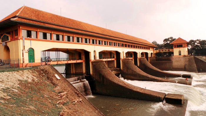 Kompas/DEDI MUHTADIThe Walahar Dam receives water from the Citarum River from the Curug Dam and splits the water for irrigation in the North West Tarum and North East Tarum channels. The two irrigation channels supply water to 83,000 hectares of rice field in Karawang. This photo was taken on Feb. 19, 2014.
The real hard work was, of course, increasing the productivity of rice cultivation. Before, there had been only one planting period a year. After the Walahar Dam was completed, there could be more than one planting period.
As written on its wall, the Walahar Dam was inaugurated on Nov. 30, 1925. The two-year construction of the dam had been overseen by Dutch hydrologist C. Swaan-Koopman.
According to the book Irrigation History of Indonesia (2004), the Walahar Dam was one of 19 dams in Java that were built in 1920. Four of these dams were constructed in West Java, namely on the rivers Citarum, Cipunegara, Cimanuk and Cilutung.
The Walahar Dam supplies water for 87,506 hectares of rice field – equal to around 1,000 times the size of the National Monument (Monas) square in Jakarta.
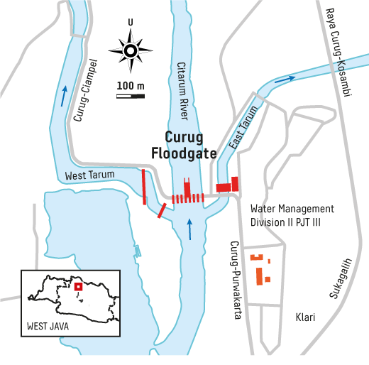
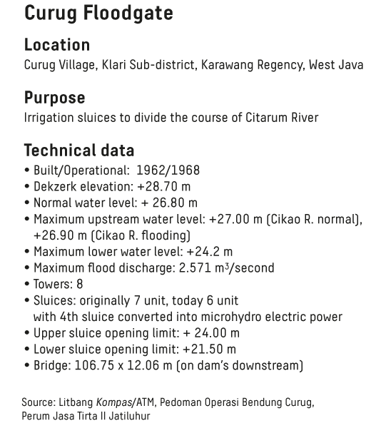
Curug Floodgate
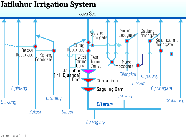
Constructed in 1965, the Curug Dam splits the Citarum River into three channels, namely the Central Tarum, West Tarum and East Tarum. The Central Tarum is the original Citarum watershed area. The West Tarum stretches 68.67 km to Jakarta and the East Tarum stretches 67.37 km.
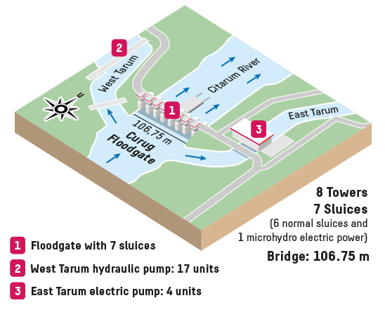
The West Tarum channels water from the Citarum River to Jakarta, the nation’s capital. It is also designed to supply water to 56,628 ha of rice fields
The East Tarum channel, on the other hand, supplies water to 90,230 ha of rice fields. The East Tarum caters to farmers in Karawang, Subang and Indramayu regencies.
In 1939, Van Blommestein thought about how to convey water from the west all the way to the east on Java’s northern shores. Blommestein planned to use hydraulic pumps powered by the water current (Book: Portrait of Construction Services in Indonesia: An Aligned Approach, 2010).
Professor Sedyatmo then modified the idea by creating a new design of hydraulic pumps. This new design is unique in that the tilt of the pumps is changed to 45 degrees, resulting in more power to feed water into the main channels.
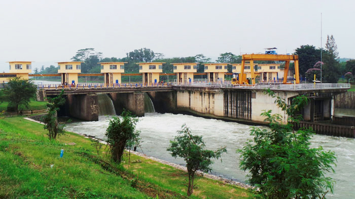 Kompas/DEDI MUHTADIThe Curug Dam in Karawang regency splits water from the Jatiluhur Dam into the West Tarum and East Tarum irrigation channels. Water in the West Tarum channel flows to Kali Malang to supply Jakarta’s drinking water. This photo was taken on Feb. 19, 2014.
“The general structure of the pumps is very conventional and, without a doubt, this turbine-pump installation is the most important of its kind in the world,” L. Puyo, the director of French company Neyrpic, said when studying Sedyatmo’s design (Kompas, Oct. 29, 1966).
The winner of the project tender is Ferrostaal AG from Essen, Germany. Unsurprisingly, the loan for the water pumps was later obtained from Germany (or, at the time, West Germany).
Jatiluhur
“I have a message to all laborers, in that hopefully all laborers give all their energy to the implementation of this project. Please remember that this project does not belong to just one capitalist, but it is a project of the state, of the people, of all of us,” said Indonesia’s founding father Soekarno when visiting the Jatiluhur Dam construction project on September 19, 1965.
From his speech, it was apparent that Soekarno wished for speedy completion of the Jatiluhur Dam, as it was key to increasing agricultural productivity as well as to reducing floods and fulfilling raw water needs.
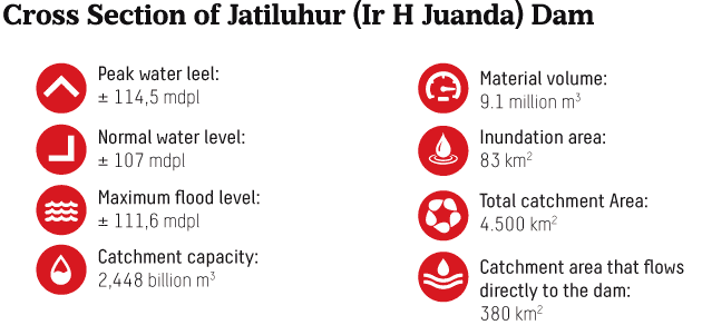
Designed by Van Blommestein in 1930, the Jatiluhur Dam irrigates 8,300 ha.
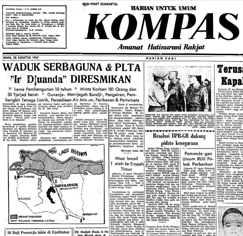
Jatiluhur was first designed to supply water to 517,240 ha of rice fields. However, when President Soeharto inaugurated the dam on Aug. 26, 1967, only 240,000 ha of area was left. It was a significant reduction, but it remained vast and in prime condition.
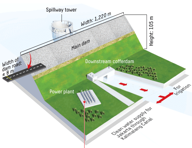
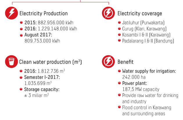
Apart from serving as a source of irrigation water, Jatiluhur also supplies water to a 187-megawatt hydropower plant.
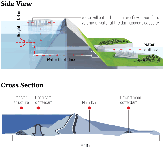
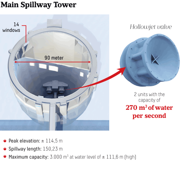
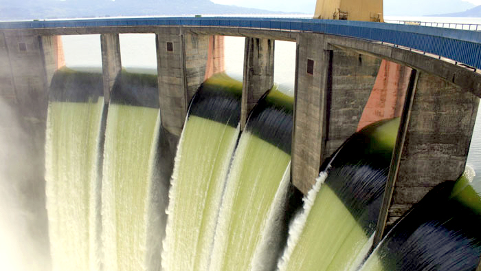 Kompas/MUKHAMAD KURNIAWANWater in the main dam of Ir. H Djuanda Jatiluhur Dam in Purwakarta regency, West Java, overflows on Sunday (22/3/2010). The water level at the dam on Sunday (21/3) evening reached 108.41 meters above sea level, the highest it has ever been during the dam’s 47 years of operation.
 Kompas/LUCKY PRANSISKAThe Ir. H Juanda Jatiluhur Dam in Jatiluhur district, Purwakarta regency, West Java, on Friday (26/3/2010). The Jatlihur Dam is the largest dam in Indonesia, built on an 8,300-hectare lake. Six turbines with a total installed power of 187 megawatts and total electricity production of 1,000 million kilowatt-hours are installed in the dam under management by state electricity firm PT PLN.
 President Soeharto said that Jatiluhur, which today remains the largest dam in Indonesia, was the fruit of Indonesian national labor. “This giant structure is the manifestation of mutual assistance between the government and the people. It also symbolizes the cooperation and friendship between the Indonesian and French governments and people,” Soeharto said when inaugurating the dam.
Jatiluhur’s construction was funded by a US$130-million loan from France as well as domestic funding of Rp 50 billion in old currency and Rp 50 million in new currency. For comparison, the price of a new 1967 Holden was $2,000 or around Rp 280,000
Cirata Dam
Cirata Dam began operating on March 23, 1989. The dam irrigates 6,200 ha of land, and the government relocated 10,100 families. Water in the dam is used to power a hydropower plant with a total power of 1,008 MW, or 8 x 126 MW.
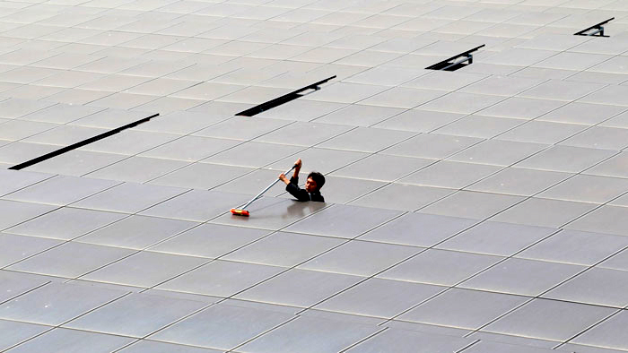 Kompas/Totok Wijayanto Officers tend to solar panels at the Cirata solar power plant in Purwakarta, West Java, on Sunday (25/10/2015). The power plant, with a capacity of 1 megawatt and belonging to state electricity firm PT PLN subsidiary PT Pembangkit Jawa Bali, is the largest of its kind in Java.
 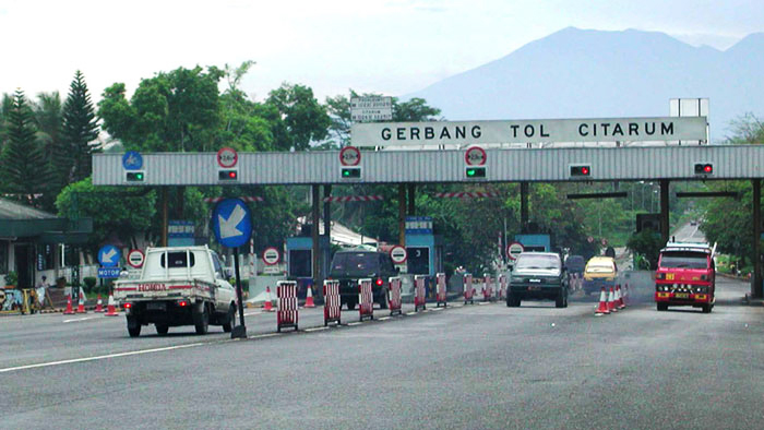 Kompas/Jean RizalMotorists question the purpose of the Citarum toll road at Rajamandala, Cianjur, and the toll fee of Rp 500 (3.65 US cents). The Citarum toll road was unusual, as it does not function as a freeway. Pedestrians and motorbike users can pass through the toll gate. Given the lack of adequate infrastructure, motorists are questioning the use of the toll fee. This photo was taken on April 17, 2002.
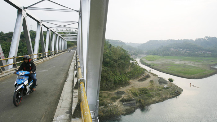 Kompas/AGUS SUSANTOPeople pass across the Citarum Rajamandala bridge in Haurwangi district, Cianjur regency, West Java, on Thursday (31/7/2008). A decades-old road built on Dutch governor-general Daendels’ orders is located far below and it has become increasingly eroded by the Citarum’s water flow.
Saguling Dam
The Saguling Dam began operating on July 24, 1986. The dam irrigates 5,600 ha of land, and the government relocated around 3,709 families. Water in the dam is used to power a hydropower plant with a total power of 700-1,400 MW.
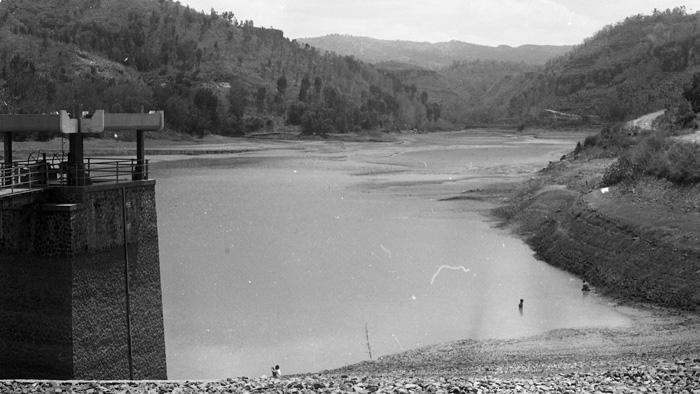 Kompas/Thomas Pudjo WidijantoThe impact of the long drought in 1987 increasingly felt. In September 1987, the high water level of Saguling Reservoir (Dam) in West Java continued to shrink 15-20 cm per day.
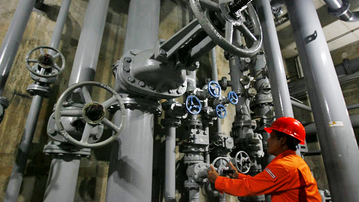 Kompas/LUCKY PRANSISKAOperator Anwar Budiman adjusts the water coolant for the generators at the Saguling hydropower plant in Bandung regency, West Java, on Friday (26/3/2010). The power plant, owned by power company PT Indonesia Power, has an installed capacity of 700 megawatts and supplies electricity to Java and Bali.
Hundreds of hectares of rice field in Karawang regency, West Java, were hit by flooding from the Citarum River several years ago. Questions arise. There are three large dams in Citarum River, namely Jatiluhur, Cirata and Saguling. Why were these dams ineffective in preventing flooding?
Now, for the sake of the future of tens of millions of people in the Citarum watershed area, infrastructure is being improved. The Public Works and Public Housing Ministry continues to design and construct new infrastructure, including river restoration, retention pools and tunnels.
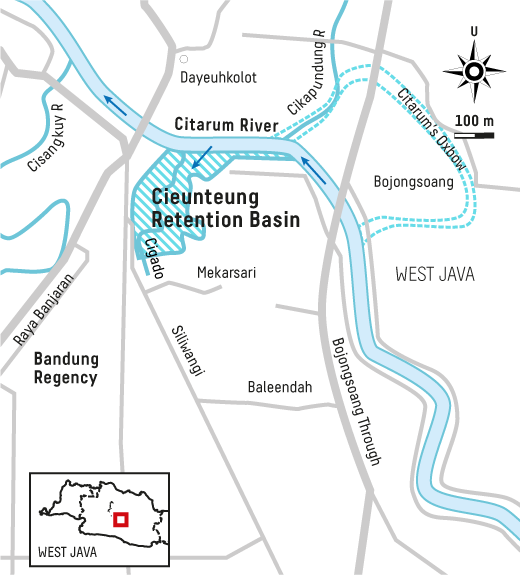
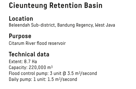
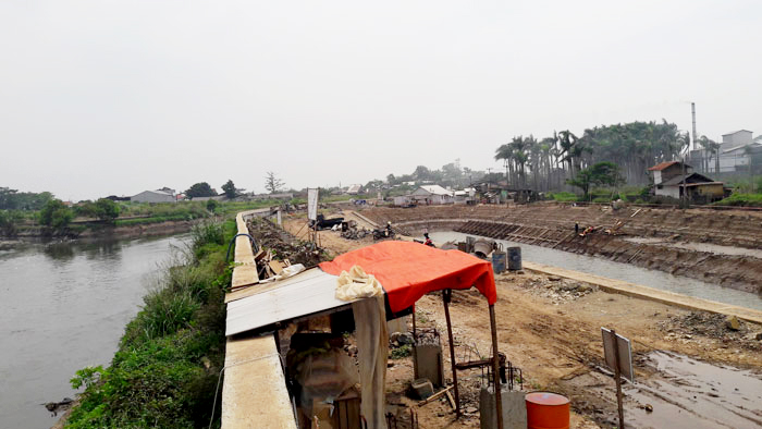 Kompas/BENEDIKTUS KRISNAWorkers complete the construction of a drain retention pool in Cieunteung hamlet, Baleendah district, Bandung regency, on Friday (29/2/2017). The 8-hectare pool contains water from Citarum’s tributaries to prevent flooding in local villages in the rainy season. Construction is expected to complete in late 2018.
The question is that, is infrastructure the only solution for flood prevention and river management? Are rivers only controllable by infrastructure? How many billions or trillions of rupiah must be disbursed for this?
Infrastructure development should have been calculated thoroughly. Better not to build dams, for instance, on a river with a heavily damaged upstream region and severe erosion. Better not build irrigation culverts without assured water supply.
Besides, the role of citizens in protecting rivers must be improved. Without people’s involvement, infrastructure development will be in vain.